Sericocarpus rigidus Lindl.
white-top aster
Asteraceae (Aster family)
Introduction to Vascular Plants
white-top aster
Asteraceae (Aster family)
Introduction to Vascular Plants
A blue-listed taxon in BC
Species Information click to expand contents
General:
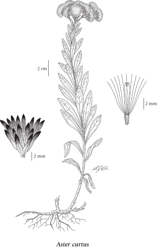
Perennial herb from a slender, creeping rhizome; stems erect to ascending, glabrous, 10-30 cm tall.
Leaves:
Basal leaves reduced and soon deciduous; stem leaves oblanceolate, tapering to an essentially unstalked base, somewhat 3-nerved, entire, often slightly stiff-hairy on the midrib below, 2.5-3.5 cm long, 5-9 mm wide, gradually reduced upwards.
Flowers:
Heads with ray and disk flowers, several to many in a terminal cluster or rarely more branched; involucres 7-9 mm tall; involucral bracts graduated in several series, with a strong midrib or slight keel, oblong or the inner linear, obtuse to abruptly sharp-pointed, white and papery below, the light green tip often loose and spreading; ray flowers inconspicuous, 1-3 (typically 2), shorter than the pappus, white, 1-3 mm long; disk flowers few, 9-21, pale yellow with purple anthers, shorter than the pappus.
Fruits:
Achenes smooth, densely grey-hairy; pappus white.
Illustration click to expand contents
If more than one illustration is available for a species (e.g., separate illustrations were provided for two subspecies) then links to the separate images will be provided below. Note that individual subspecies or varietal illustrations are not always available.
Illustration Source: The Illustrated Flora of British Columbia
Ecology click to expand contents
Ecological Framework for Sericocarpus rigidus
The table below shows the species-specific information calculated from
original data (BEC database) provided by the BC Ministry of Forests and Range.
(Updated August, 2013)
The table below shows the species-specific information calculated from
original data (BEC database) provided by the BC Ministry of Forests and Range.
(Updated August, 2013)
| Site Information |
Value / Class |
||
|
Avg |
Min |
Max |
|
| Elevation
(metres) |
519 | 92 | 960 |
| Slope
Gradient (%) |
29 | 0 | 84 |
|
Aspect (degrees) |
275 | 45 | 313 |
| Soil
Moisture Regime (SMR) [0 - very xeric; 4 - mesic; 8 - hydric] |
3 | 2 | 5 |
| Modal
Nutrient Regime
Class |
D | ||
| #
of field plots species was recorded in: |
6 | ||
| Modal
BEC Zone Class |
IDF | ||
|
All BEC Zones (# of stations/zone) species was recorded in |
CDF(2), IDF(4) | ||
|
Source:
Klinkenberg 2013
|
|||
Habitat and Range click to expand contents
Dry meadows, woodlands and rocky slopes in the lowland zone; rare on S Vancouver Island, and adjacent Hornby Island and Trial Island; S to OR. This last part of the Aster key (often referred to as the A. occidentalis complex) contains some of the most variable and complex taxa in Asteraceae. The many intermediates between two or more species result in numerous plants which are difficult to place.
Status Information click to expand contents
| Origin Status | Provincial Status | BC List (Red Blue List) | COSEWIC |
|---|---|---|---|
| Native | S3 | Blue | SC (Apr 2009) |
BC Ministry of Environment: BC Species and Ecosystems Explorer.
Synonyms click to expand contents
Synonyms and Alternate Names:
Sericocarpus rigidus
Aster curtus Cronquist
Similar Species click to expand contents
Aster curtus is easily distinguished from other asters in BC by its few (1-3), short (1-3 mm), white ray flowers that are obscured by the taller pappus. Aster engelmannii has white flowers but is a much taller plant (60-120 cm tall) with longer (15-25 mm) ray flowers. Aster paucicapitatus also has white flowers but there are more of them (8-21) and the rays are longer (10-15 mm). In addition, their habitat preferences and ranges are vastly different in BC. Aster curtus occurs in Garry oak woodlands in coastal BC and A. engelmannii occurs in and east of the Coast-Cascade Mts in meadows, avalanche tracks and open forests. Aster paucicapitatus occurs in coastal BC, but in meadows and outcrops in the mountains on Vancouver Island.
Source: British Columbia Conservation Data Centre |