© Bryan Kelly-McArthur
Click to enlarge and view the photo details
View all photos for this taxon
E-Flora BC Static Map Dendrolycopodium dendroideum Click here to view our interactive map and legend
Details about map content are available here Click on the map dots to view record details.
Open All Headings Close All Headings
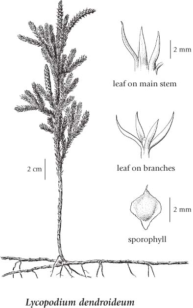
Click on the image below to view an
expanded illustration for this species.
General:
Leaves:
Cones:
Source: The Illustrated Flora of British Columbia
Dry to moist forests, bog edges, rocky or sandy places in the lowland to montane zones; frequent on N coast and in C BC, infrequent elsewhere; amphiberingian, N to AK, YT and NT, E to NF and S to MA. NH, PA, NC, TN, MO, SD, WY, ID and WA; E Asia. Source: The Illustrated Flora of British Columbia
Ecological Framework for Dendrolycopodium dendroideum The table below shows the species-specific information calculated from
original data (
BEC database ) provided by the BC Ministry of Forests and Range.
(Updated August, 2013)
Site Information
Value / Class
Minimum
Average
Maximum
Elevation
(metres)
5 653 2292
Slope
Gradient (%)
0 12 75
Aspect (degrees)
0 313 360
Soil
Moisture Regime (SMR )
0 3 7
Modal
Nutrient Regime
C
Number
of field plots
353
Modal
BEC Zone Class
ICH
All BEC Zones (# of stations/zone) species was recorded in:
AT(1), BAFA(2), BWBS(19), CWH(44), ESSF(13), ICH(137), SBS(124), SWB(3)
Lycopodium dendroideum Michx.