
CITIZEN SCIENCE ON E-FAUNA BC:
MAPPING PHOTO RECORDS
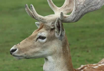
Fallow Deer (Dama dama), photo by Diane Williamson.
Introduction
Citizen science or, as geographers call it, volunteered geographic information (VGI) is a growing area in biodiversity documentation. Citizen scientists are now collecting fundamental and significant biological data that can be added to our biodiversity knowledge base. This sort of volunteered geographic information can aid scientists and can lead to comprehensive databases of information that result in greater understanding of species and their habitats, and can ultimately lead to better protection and management efforts.
Citizen Science and VGI on E-Flauna BC
On E-Fauna BC, we are now mapping photo records. These records appear on our interactive maps as a new and growing data layer. While species distributions are generally mapped from specimen records, and specimen records are the most important scientific documentation of species occurrences, photo records can provide significant information and observations on a species that can then be followed up by experts.
How does this work?
If you submit photos to E-Fauna BC and include precise location information (coordinates) with your photo, then a dot will appear on our interactive map that displays your record. Users will be able to access the details that accompany the photo directly from the interactive map. Mapped photo records will appear on the interactive maps as their own data layer.
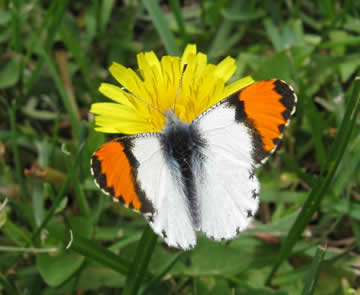
Sara's orangtip (Anthocharis sara flora ), photo by Jeremy Gatten
How do I participate in this Citizen Science initiative?
This is easy--when you submit your photo, just add a bit more information to your photo details. That is, include the precise location information for the site where the photo was taken. Details on how to do this are presented below.
How do I determine precise location?
In order to map your photo record, we need specific location information such as the UTM coordinate or the latitude and longitude (note that latitude and longitude would be the preferred choice, as UTM coordinates require additional information [the zone #] in order to be useful). Those with GPS units will find this information easy to obtain for each photo. If you don't have a GPS, this information can be determined in one of two ways.
1) by using topographic maps to determine precise location information. You can purchase these for your region through government bookstores. (Instructions on how to obtain UTM coordinates off-of a topo map can be found here.)
2) by using Google Maps to determine that information: go to maps.google.com, select the Satellite view, then zoom into where you took the photo (hold the cursor down to move the map around), or type in a name in 'search maps' box. You can then either:
a) right-mouse click over the spot where you took the photo, and select What's here? Then, click on the green arrow that appears, and the latitude and longitude are revealed. or
b) use the Canadensys LatLong Crosshairs toolbar (explained here).
If you are interested in contributing to this sort of citizen science information gathering, you can go back and add precise location information to any of your photos that are already in our database. Photo records in our database that already have this information will be mapped automatically.
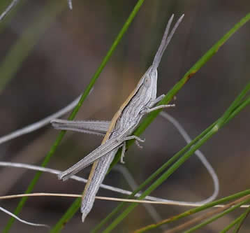
Toothpick grasshopper (Pseudopomala brachyptera), photo by Brian Klinkenberg
How can I improve the accuracy level of my photo records?
The value of data, including citizen-collected data, is based on its accuracy and reliability levels. In our case, this means that the accuracy of the identification of the species in the photos in our photo gallery is of prime importance. At E-Fauna BC, we work with many experts to vet photo identifications and ensure that our accuracy level is high. All photos are reviewed and, where identification to the species level cannot be made or is too uncertain, a photos may not be published.
You can help improve accuracy of photos on E-Fauna by providing photos that help our photo reviewers make or confirm identifications. The most beautiful photos may not show key features our reviewers need to confirm or make an identification. Because of this, it can be helpful for more difficult groups to send in a set of photos, including your best shots as well as shots that show detail. For groups such as insects or marine invertebrates, it helps to submit additional shots that show different aspects of a species. For example, photos of the underside as well as the top side, close ups of the legs, or clear shots of the eyes. For leeches, for example, the eyes are important in identification and photos are best taken with the leech in the water. We may not publish all of the photos you submit in a photo set, but they can be very helpful in our photo review process.
Most importantly, we need clear, unblurred photos to help our reviewers see the parts of the animal they need in order to make an identification. Blurry photos will not be published.
Please cite these pages as:
Author, date, page title. In: Klinkenberg, Brian. (Editor) 2023. E-Fauna BC: Electronic Atlas of the Fauna of British Columbia [www.efauna.bc.ca]. Department of Geography, University of British Columbia, Vancouver. [Date Accessed]
© Copyright 2023 E-Fauna BC.