
E-FLORA PHOTOS AS CITIZEN SCIENCE:
MAPPING YOUR PHOTO RECORDS
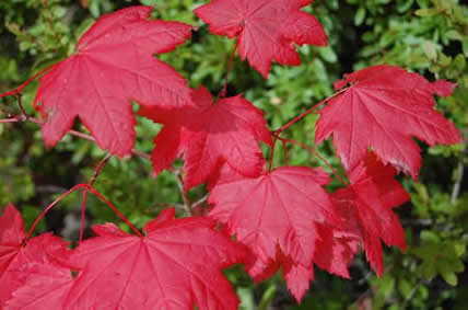
Vine maple (Acer circinatum), photo by Kevin DeBoer.
Learn how to submit photos to E-Flora BC here.
Introduction
Citizen science or, as geographers call it, volunteered geographic information (VGI) is a growing area in biodiversity documentation. Citizen scientists are now collecting fundamental and significant biological data that can be added to our biodiversity knowledge base. This sort of volunteered geographic information can aid scientists and can lead to comprehensive databases of information that result in greater understanding of species and their habitats, and can ultimately lead to better protection and management efforts.
Citizen Science and VGI on E-Flora BC
On E-Flora BC, we are now mapping photo records, and you can become a citizen scientist by participating in this. Mapped photo records appear on our interactive maps as a new and growing data layer. While species distributions are generally mapped from specimen records, and specimen records are the most important scientific documentation of species occurrences, photo records can provide significant information and observations on species that can then be followed up by experts.
Which photo records would we like to map?
While we can map any photo record of a species, we are particularly interested in mapping significant photo records. That is, photo records that document range changes and that fill in gaps in species distributions. If you have a photo record that shows, for example, the occurrence of a species that is further north than our present mapping shows, or that documents a record of a species in a region where it is not known, then we would like to map it. Mapping photo records is particularly valuable for groups like invasive plants, where some species are moving quickly into new territory as the climate changes. It is also valuable for species at risk where mapping of new sites is important for protection and management. Photo record mapping will be particularly useful for adding dots to distribution maps that are presently blank. Your photo records will give insights into where these species occur in BC.
How does this work?
If you submit photos to E-Flora and include precise location information (UTM coordinates or latitude/longitude), then we will map your photo record. A dot will appear on our interactive map. Mapped photo records are included in our interactive maps as their own data layer. This allows users and experts to easily sort out which distribution records are based on photos and not on specimens.
What geographical regions do we cover?
We presently map photo records primarily for the Pacific Northwest but do include other adjacent regions where this information is available in the databases we have downloaded.
Concerned about showing rare species locations?
Concerns about mapping locations of rare species that would allow unethical collection of specimens are valid. If you are concerned about providing location information for a particular species that you feel might be a target, then your data can include less precise coordinate information that only shows general locality. The dot that this produces on our maps will still be important for showing new regions and occurrences even at a more general level.
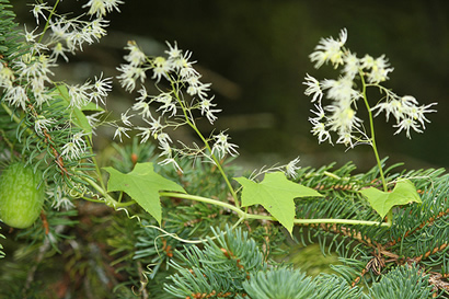
Wild Cucumber (Echinocystis lobata), photo by Brian Klinkenberg. This photo shows the flower arrangement, leaf shape and trailing nature of the plant.
How do I participate in this citizen science component?
Participation is simple. If you feel that your record of a species is significant, then just include location coordinate information (latitude/longitude or UTM info) in the photo details section of the upload form when you upload your photo. Your dot will appear on the species map the next time we update our mapping databases (monthly). Note that you only need to enter coordinates for one photo of a species from a particular location. Use less specific coordinates for species of concern.
How do I determine location coordinates?
In order to map your photo record, we need location information such as the UTM coordinate or the latitude and longitude (note that latitude and longitude would be the preferred choice, as UTM coordinates require additional information [the zone #] in order to be useful). Those with GPS units will find this information easy to obtain for each photo. If you don't have a GPS, this information can be determined in one of two ways.
1) by using topographic maps. You can purchase these for your region through government bookstores. (Instructions on how to obtain UTM coordinates from a topographic map can be found here.)
2) by using Google Maps. Go to maps.google.com, select the Satellite view, then zoom into where you took the photo (hold the cursor down to move the map around), or type in a name in the 'search maps' box. You can then either:
a) Right-mouse click over the spot where you took the photo, and select What's here? (On a Mac, pressing the control key and then clicking on the spot [control-click] is the same as right-mouse clicking on a PC.) Then click on the green arrow that appears and the latitude and longitude are revealed, or
b) Use the Canadensys LatLong Crosshairs toolbar (explained here).
If you are interested in contributing to this sort of citizen science information gathering, you can go back and add precise location information to any of your photos that are already in our database. Use the "Edit My Photos" link on the Photo Upload page to access your photos. Click on a thumbnail to open the editing page and add information.
Photos in our database that already have coordinates will be mapped automatically.
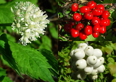
Red baneberry (Actea rubra), photo by Alfred Cook. This photo shows flower structure and colour, fruit colour variation, and leaf shape and toothing.
How can I improve the accuracy level of my photo records?
The value of data, including citizen-collected data, is based on its accuracy and reliability levels. In our case, this means that the accuracy of the identification of the species in the photos in our photo gallery is of prime importance. At E-Flora BC, we work with many experts to vet photo identifications and ensure that our accuracy level is high. All photos are reviewed and, where identification to the species level cannot be made or is too uncertain, a photos may not be published.
You can help improve accuracy of photos on E-Flora by providing comprehensive photo coverage that aids our photo reviewers. When you submit a photo, it is helpful to submit additional shots that show different aspects of a plant. For example, photos of the whole plant and of the various parts of the plant are useful in checking identifications. These additional photos may be of leaves, stems, roots, seeds and flowers. We may not publish all of these photos, but they are important in vetting the identifications of species in the photos.
If you want to take your contribution level up a notch, and improve accuracy levels even further, then it is very useful to photograph key or taxonomic features of a species. These are features that help separate one species from another scientifically. This might be the presence or absence of hairs on the leaves, the types of hairs (long or short), or presence or absence of rhizomes. If you are uncertain what these key features are for your species, check the species information on the E-Flora atlas pages or check a field guide. Species descriptions usually point them out. If these key features are difficult to photograph, then describe them in the comments box when you upload a photo. The more information you include in the comments section, the better.
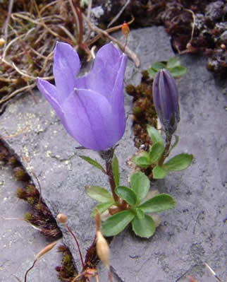
Mountain harebell (Campanula lasiocarpa), photo by Allan Carson. This photo show flower size relative to leaf size, leaf size and shape, and provides some indication of habitat.
Recommended citation: Author, date, page title. In: Klinkenberg, Brian. (Editor) 2023. E-Flora BC: Electronic Atlas of the Flora of British Columbia [eflora.bc.ca]. Lab for Advanced Spatial Analysis, Department of Geography, University of British Columbia, Vancouver. [Date Accessed]
E-Flora BC: An initiative of the Spatial Data Lab, Department of Geography UBC, and the UBC Herbarium.
© Copyright 2023 E-Flora BC.